The name Hund is derived from the word Hind, which in Sanskrit means “water”—a reference to its proximity to the mighty Indus River. Throughout history, the city’s name has appeared in various forms, including Auhind, Wayhind, Awand, Wand, Widhanda Pura, Wadhan Pur, and Wudbhanda Pur, all sharing similar phonetic roots.
In Firdausi’s Shahnama, it is referred to as Mehind, while Arab historians mention Wehind as the capital of Gandhara. According to Rashid-ud-Din, the Mongols held Hund in such high regard that they named it Karajang. The only known native historian to use an abbreviated version of the name is Nizamuddin, who writes in his Tabakat-i-Akbari that Mahmud of Ghazni besieged Raja Jaipal in the fort of Hind in 1002 CE.
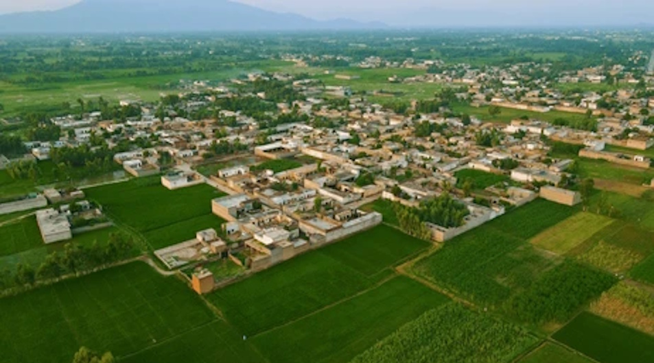
Strategic Importance of Hund
What made Hund so vital to ancient invaders like Alexander the Great? Geography holds the answer.
At this point, the River Indus is both narrow and shallow, making it one of the easiest crossing points. In antiquity, Hund lay at the foot of the Swat region, serving as the shortest route for invaders and merchants traveling between China, Persia, and the Indian subcontinent. Buddhist monks also used this route to bring their teachings from Tibet to the broader region.
The fertile soil around Hund yielded abundant crops, fruits, and vegetables, making it an ideal site for any kingdom to establish its capital and military base.
In the spring of 326 BCE, Alexander of Macedonia arrived at the formidable River Indus after crossing the mountains of present-day Afghanistan. The historian Arrian describes the river as “bigger than any river in Europe, a mighty stream which imposes its name upon the country as it flows down to meet the sea.”
Alexander reunited with his generals Hephaestion and Perdiccas at the town of Ohind, who had been sent ahead through the Khyber Pass to gather supplies and construct a bridge. This bridge had to support an entire army of around 64,000 infantry, 12,000 cavalry, and a long caravan of siege equipment and supplies.
At the time, the local ruler was Raja Ambhi, who welcomed the Macedonians due to his ongoing conflict with Raja Porus of Jehlum. The region, referred to by Arrian as Embolium or Ambhi’s country, still echoes Ambhi’s name in places like Ambaar, Ambh Darband, and Ambela.
Rise and Decline
In the first century CE, warrior tribes from beyond the Oxus River (Amu Darya) invaded northern Afghanistan and established the Kushan Empire in northern India. Their most renowned king, Kanishka, was a patron of Buddhism, and Hund became a center for Buddhist monks and scholars.
The Kushan Empire eventually fragmented in the 3rd century CE under the reign of Vasudeva. The region was later attacked by the Sassanians from Iran, and Hund came under their control, with the local populace being mostly Brahman and Buddhist.
In the 5th century, the Ephthalites or White Huns from Central Asia seized the region. Chinese pilgrim Sung-Yun visited in 520 CE when the Huns ruled Gandhara. The Hindu Shahi kings later made Hund the capital of Gandhara.
The Chinese monk Hiuen Tsang, who visited in the 7th century, found no trace of the Kushans. He referred to Peshawar as Polusha and mentioned Udakhanda—believed to be Hund. At the time, the city covered a 3-mile circuit and grew during the Brahman period.
English archaeologist Alexander Cunningham, who surveyed the area in the 19th century, described Hund as “littered with the ruins of Buddhist monasteries and temples.” In the sands at the foot of the cliffs, he noted, gold washers found coins and ornaments—evidence of the city’s former prosperity. Indo-Scythian coins from the early Common Era were frequently uncovered.
In 1841, the British traveler Alexander Burnes described Sanskrit inscriptions found on marble pieces at Hund. These were later deciphered in Calcutta and dated to the 7th–8th centuries CE, referencing a nameless hero who defeated the “powerful Turuschas” (Turks).
Coins, jewelry, and other artifacts belonging to Indo-Scythian and Hindu Shahi rulers have been found in the area.
By the 10th century, Islam had started to take root in Hund. In Hudud al-‘Alam (982 CE), Jozjani describes Wehind as a large city, ruled by Raja Jaipal, a vassal of the King of Kannauj, with a small Muslim population. Arab historian Al-Muqaddasi wrote in 985 CE that Hund was larger than Mansura, with flat lands and beautiful gardens. Al-Biruni also mentions the Indus flowing past the plains of Wehind.
In the late 10th and early 11th centuries, Subuktigin and his son Sultan Mahmud of Ghazni conquered Hund, making it the first cantonment of the Ghaznavid Empire by the Indus. Mahmud appointed his favored slave, Ayaz, as the governor of the region. Roshan Khan, a local historian, claimed Ayaz was buried in the nearby village of Toorlandai, though no grave has yet been confirmed.
Later Decline and Excavations
In the 13th century, Hund witnessed another pivotal event. Genghis Khan’s Mongol army pursued the defeated Khwarazm Shah to the banks of the Indus. The Shah, in a final act of defiance, rode his horse into the river, prompting Genghis Khan to halt his archers, saying, “There goes the brave one.”
Hund’s significance faded in the 16th century when the Mughals built the Attock Fort and established a new river crossing. Abul Fazl, court historian to Emperor Akbar, noted in the Akbarnama that the area, once a bustling city, had become a series of ruined mounds.
In the late 20th century, UNESCO and Pakistan’s Archaeology Department conducted excavations in Taxila that uncovered 15-foot-deep Neolithic pottery dating to 1200–1100 BCE, suggesting early urban settlements in the region. Similar excavations are urgently needed in Hund.
Unfortunately, modern development has led to the destruction of key archaeological sites. Locals report that a contractor for the Islamabad–Peshawar Motorway demolished a valuable mound at Hund, known as “Chapai.” Archaeologists believe this artificial hill was a signal post used during Alexander’s campaign to guide nighttime river crossings.
References:
-
Cabool: A Personal Narrative – Alexander Burnes (1841), pp. 92–93.
-
Taxila: A Historic City – Ahmad Hasan Dani, Sang-e-Meel Publications, Lahore (1991), pp. 43, 153.
-
Ancient Geography of India – Alexander Cunningham, edited by S.M. Sastri, Patna University (1924), pp. 65–67.
-
Tazkira: The Origins and History of the Pathans – Khan Roshan Khan (1983), Roshan Khan & Co., Karachi.
Support Dawat Media Center
If there were ever a time to join us, it is now. Every contribution, however big or small, powers our journalism and sustains our future. Support the Dawat Media Center from as little as $/€10 – it only takes a minute. If you can, please consider supporting us with a regular amount each month. Thank you
DNB Bank AC # 0530 2294668
Account for international payments: NO15 0530 2294 668
Vipps: #557320
Comments are closed.